Trek Highlights
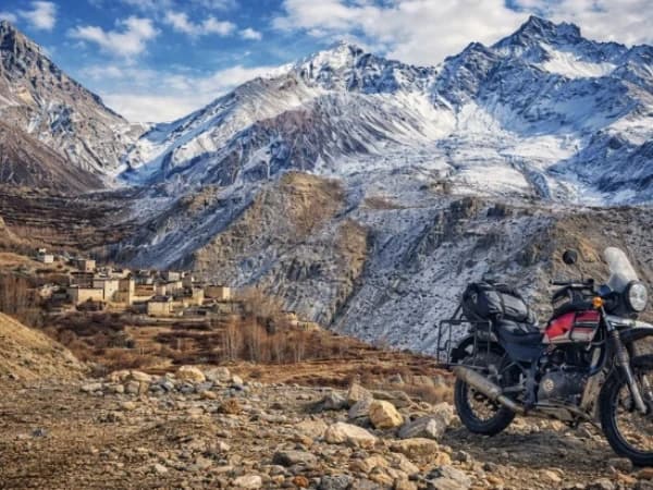
- 10-day private trek through Nepal’s restricted Mustang region, including 4 nights at Lo Manthang, the walled medieval capital of the former Kingdom of Mustang.
- Restricted area permit included in your tier price (USD 50 per day, paid to the Nepal government for the days you are inside Upper Mustang). The fee funds local development and is the reason the region has not been overrun.
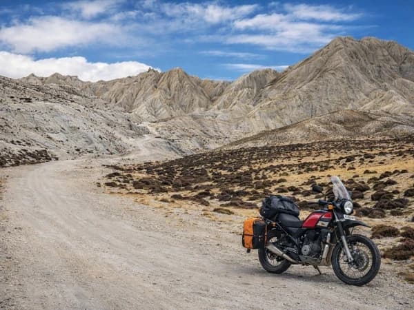
- Dry rain-shadow landscape that feels physically and culturally like the Tibetan plateau. Closed to outsiders until 1991.
- Private guide and porter ratio that does not change based on group size. No shared-group surcharge gimmicks.
- 10% deposit to lock dates, balance paid in person in Kathmandu. No full prepayment required to a foreign trekker you have never met.
- Every booking helps fund our Nagarjun Learning Center work at Saldum, where 70 children are taught by one dedicated teacher.
Why I built this trek the way I did
I am Shreejan, the founder of The Everest Holiday. Upper Mustang is the most expensive permit-fee region we work in. The Nepal government charges USD 50 per person per day for the restricted area permit, billed only for the days you are inside Upper Mustang. We pay this permit cost upfront for you and include it in the tier price. It is one of the reasons the trek looks more expensive than a standard Annapurna trek of similar length.
The cost is real, but so is what you get for it. Upper Mustang is the only part of Nepal that still feels physically and culturally like the Tibetan plateau. The walled city of Lo Manthang, the chortens and cave monasteries, the dry red-rock landscape, the language people still speak in their kitchens. None of this exists anywhere else in Nepal that is currently open to trekkers. The region was completely closed to outsiders until 1991. The permit fee funds local development and is the reason it has not been overrun in the way other regions have.
I run this as 10 days because the road to Jomsom has shortened the access window without changing the cultural depth of what is north of Kagbeni. Days 1 to 3 get you in. Days 4 to 7 are the real trek through Mustang’s villages. Days 8 to 10 bring you back out. The 10-day shape respects both your time budget and the time you actually need at Lo Manthang to absorb where you are.
We run this as a private trek only. No shared-group commitment. Your pace, your rest days, your conversations at dinner. We do not change the guide-to-porter ratio when the group is smaller. Your guide and porter are with you whether you are two people or six.
Every booking on this trip helps us pay the teacher’s salary at our Nagarjun Learning Center in Saldum, where 70 children get free education. The salary is currently funded out of my own pocket. Your trek is what makes that sustainable.
“I had the most amazing experience with The Everest Holiday and its guide Shreejan. He is like a brother to me ever since I met him in 2018.”
— Angelica Rayment · Verified TripAdvisor Review, September 2024 · ★★★★★
The Upper Mustang Trek takes you on an extraordinary trek through the old Kingdom of Lo, which is one of Nepal's most remote and culturally rich areas. This desert terrain is very different from the lush foliage that is common in Nepal. It is located in the rain shadow of the Himalayas. Upper Mustang has been a restricted area for hundreds of years, which has helped keep its distinctive Tibetan Buddhist culture, old monasteries, and ancient caverns on the cliffs. Today, it is a top teahouse excursion for people who want to explore culture and history up close and personal, away from the masses.
What Makes This Trek Special
- major pilgrimage sites like Muktinath, Kagbeni, Talbarahi temple, and many more.
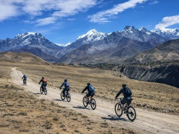
- A varied terrain from tropical forest to alpine terrain to mountain.
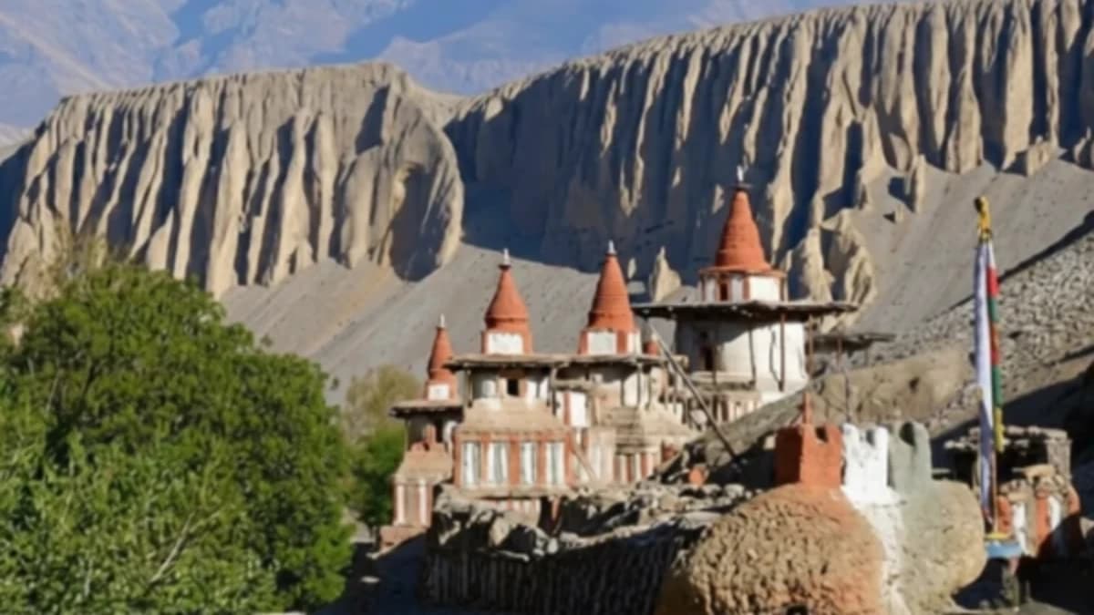
- Going to the old walled city of Lo Manthang.
- Seeing the one-of-a-kind high desert terrain.
- Finding old cave homes.
- Seeing the Tiji Festival (if you get the timing right).
- Crossing the high passes of Nyi La (4,010m) and Lo La (3,950m) on the way to and from Lo Manthang.
- Visiting the holy Muktinath Temple.
- Walking along the Kali Gandaki valley, the deepest gorge in the world, with Dhaulagiri (8,167m) and Annapurna I (8,091m) on either side.
- Seeing wide vistas of the Annapurna and Dhaulagiri mountains.
- Experiencing Tibetan Buddhist culture that has been maintained.
- An authentic Himalayan experience away from the crowded teahouse routes of the Annapurna and Everest regions.
10-Day Upper Mustang Trek Overview
Explore Upper Mustang, a region of Nepal that remained isolated from the rest of the world until 1992. This secluded area is sometimes nicknamed the "Last Forbidden Kingdom." It keeps Tibetan Buddhist culture alive in its purest form through old monasteries, medieval palaces, and traditional villages that have remained unchanged over time. The terrain is very different from what you would expect to see in the Himalayas. It's a beautiful high-altitude desert with eroded cliffs, deep valleys, and huge, dry plateaus. This walk is more than just an adventure; it's a deep cultural experience that lets you see how the Loba people live, speak, and practice their religion, which are all part of a deep Tibetan legacy.
The hike brings you into the Himalayas' rain shadow, where the rocks change into a beautiful mix of red, brown, and ochre. After the Kali Gandaki valley, which is the deepest valley in the world, you'll walk over pathways that are blown by the wind and have amazing views of big mountains like Dhaulagiri, Annapurna, and Nilgiri. This area has a unique trans-Himalayan ecology, showcasing uncommon plants, historic cave homes, and rocks adorned with prayer flags. The architecture of Mustang, with its whitewashed buildings, beautifully carved entrances, and mountain fortifications, is a mix of Nepalese and Tibetan styles. Such diversity makes it a wonderful place for photographers and culture lovers to visit.
Our journey starts with a beautiful drive from Pokhara to Kagbeni. The entrance to Upper Mustang and Chele is where the desert environment truly comes to life. The best part of the trip is Lo Manthang, the walled capital of the old kingdom. You will see historic monuments like the Royal Palace, Thubchen Gompa, and the Chhoser Cave Complex, which is a maze of tunnels constructed by people thousands of years ago. The way back through Ghami and Muktinath adds a spiritual element, as Muktinath is a holy place for both Hindus and Buddhists.
The Upper Mustang Trek offers a rare experience that combines raw scenery with living history. It's great for experienced trekkers and people who want to learn about different cultures. Every moment in Mustang feels like stepping into a lost period, from the lively Tiji Festival (if you schedule it properly) to the kind welcome of the Loba people. It's not only about getting to a place on this walk; it's about finding the essence of the Himalayas.
Before You Arrive
For a smooth and easy start, we highly recommend arriving in Kathmandu by 4 PM the day before we leave. This gives you enough time for a final gear check, a trip briefing with your guide, and to make sure you have everything you need before heading to the trek.
Online Briefing
This is like our first coffee before the trip, but online! This online meeting is our chance to show you everything that will happen on the trip. We will discuss everything from what gear to bring to what each day on the route will be like and how it will feel. we will answer any questions you have. After you book, we'll send you an email with a couple of times when we can talk. We'll set up the meeting after the booking process is completed. Also, our trek itinerary does not include your hotel stay in Kathmandu. During the online meeting, please share your preferences, budget, and the standard of the hotel you would like to stay at in Kathmandu. We will arrange it for you accordingly.
Your Trek, Your Way
Experience the Himalayas on your terms. We create personal, intimate treks for groups of two or more. Whether you select our Budget, Standard, or Luxury package, your adventure will be tailored exclusively for you and your companions, for a comfortable and personalized journey from start to finish.
Note on Pokhara Meals
In Pokhara, only breakfast at your hotel is included (all tiers). Lunch and dinner in Pokhara are at your own expense — we want you to have the freedom to explore Pokhara’s incredible restaurant scene on your own terms. Meals during the drive between Kathmandu and Pokhara are also not included, as there are many great stops along the way.
Kathmandu Accommodation
Your hotel in Kathmandu is not included in the trek package. During the online briefing before your trek, we will ask about your preferences and budget — whether you want a simple guesthouse or a five-star hotel — and help you arrange it. Your trek package begins when you leave Kathmandu for the mountains.
Compare Our Three Packages
| Budget | Standard | Luxury | |
|---|---|---|---|
| Price from | USD 1,290 | USD 1,930 | USD 3,500 |
| Meals | Choose your own (approx. USD 15-25/day) | 3 meals + tea + fruits + 2L water daily | All meals + all drinks anytime (except alcohol) |
| Room | Shared teahouse | Private twin w/ bathroom | Private deluxe w/ bed heater |
| Porter | Not included | 1 per 2 trekkers | 1 per trekker (carry nothing) |
| Guide | 1 guide, assistant at 8+ | 1 guide per 6, assistant at 6+ | 1 guide per 2 trekkers |
| Transport | Local vehicle | Shared tourist vehicle | Luxury private vehicle |
| SIM data | SIM only | Limited data | Unlimited data |
| Best for | Backpackers and independent travellers | Comfort trekkers, couples, families | Premium experience seekers |
Himalayas for Every Budget — same expert guides, same safety, three comfort levels.
Difficulty: Challenging (4/5)
Trek through the restricted Upper Mustang region — the former Kingdom of Lo behind the Annapurna and Dhaulagiri massifs. You will walk 5-7 hours per day across high desert terrain reaching a maximum altitude of around 4,200m at the high passes.
Where your $500 permit money cannot follow
The Upper Mustang restricted-area permit alone is $500 a person. The Nepalese government keeps that. But everything else inside our trek price has room for the things we care about — fair pay for our crew, and a fixed share for the Nagarjun Learning Center, the village school my mother runs in Saldum. Seventy children study there for free and eat two daily meals on us. We are a registered Nepalese charity, listed on the UN Partner Portal, and we have been running the school since 2019.