Trek Highlights
- 12-day private trek crossing the Thorong La Pass (5,416m), the high point of the classic Annapurna Circuit and one of the highest trekking passes in Nepal.
- Anti-clockwise rotation: the proven direction for acclimatisation. You walk up gently, cross the pass once, and descend to Muktinath through the dry Mustang-side landscape.
- Honest 12-day routing: the road has changed this trek. We start walking at Chame so you spend your time on trail, not in vehicles, while still respecting the time-budget of working travellers.
- Private guide and porter ratio that does not change based on group size. No shared-group surcharge gimmicks.
- 10% deposit to lock dates, balance paid in person in Kathmandu. No full prepayment required to a foreign trekker you have never met.
- Every booking helps fund our Nagarjun Learning Center work at Saldum, where 70 children are taught by one dedicated teacher.
Why I built this trek the way I did
I am Shreejan, the founder of The Everest Holiday. The Annapurna Circuit is the trek that taught me the most about what trekkers actually want. The road that now reaches Manang has changed this route. Operators argue about it, trekkers complain about it, and what we did was figure out how to use it without losing the experience.
The 12-day version we run starts the walk at Chame. The road still goes higher, but Chame is where the trail starts to feel like a trail again. From there to Manang you are walking through villages, apple orchards, prayer wheels, and high-altitude pasture, with the Annapurna II and III walls filling the sky on your left for three full days. The acclimatisation rest at Manang (3,540m) is where most operators rush. We do not. The day hike to the Ice Lake (4,600m) sleeps you higher for one afternoon, which is what gets you cleanly across Thorong La (5,416m) two days later.
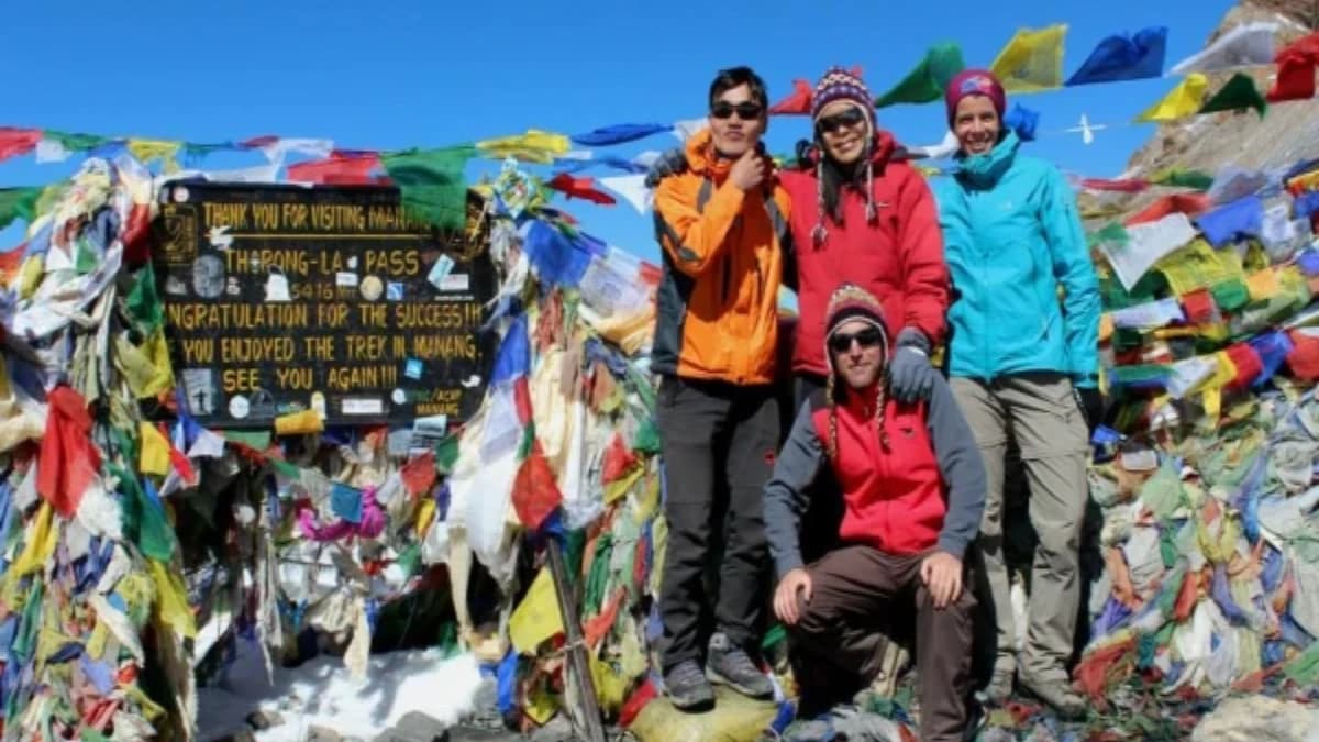
We cross Thorong La in the standard anti-clockwise direction, the same as every responsible operator on this circuit. The descent to Muktinath is where you finally see the dry side of the Annapurnas, the Tibetan-plateau-style landscape that surprises people who only know the green Nepal side.
We run this as a private trek only. No shared-group commitment. Your pace, your rest days, your conversations at dinner. We do not change the guide-to-porter ratio when the group is smaller. Your guide and porter are with you whether you are two people or six.
Every booking on this trip helps us pay the teacher’s salary at our Nagarjun Learning Center in Saldum, where 70 children get free education. The salary is currently funded out of my own pocket. Your trek is what makes that sustainable.
“I started the Annapurna Circuit Trek from Kathmandu with two guys that I met at a hostel. We met Ganesh and he invited us to his family home for dinner where we then signed up to start the adventure!”
— Conor O · Verified TripAdvisor Review, March 2025 · ★★★★★
The wind at Thorong La hits you before the view does. At 5,416 metres (17,769ft), the air is so thin that every breath feels earned, and the cold bites through every layer you are wearing. Then you look up. The entire Annapurna range stretches across the northern horizon. Annapurna I (8,091m), Annapurna II, Annapurna III, Gangapurna, and a dozen unnamed peaks shining white against a sky so blue it looks painted. Behind you, the trail you have climbed since before dawn disappears into shadow. Ahead, the long descent to Muktinath drops into a landscape so different from where you started that it feels like crossing into another country. This is not a photograph. You are standing on the highest point of the Annapurna Circuit, and the Himalayas are yours.
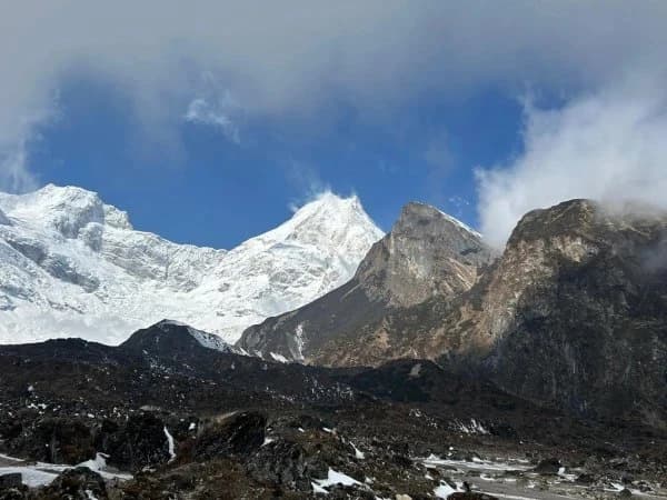
The 12-day Annapurna Circuit Trek takes you around the entire Annapurna massif through a corridor of geography that changes more dramatically than any other trek route in Nepal. You will walk through subtropical rice paddies and banana groves in the Marsyangdi valley, climb through dense rhododendron forests where Gurung and Magar villages cling to terraced hillsides, cross the high-altitude desert of the Manang valley where Tibetan Buddhist monasteries stand against barren brown cliffs, summit Thorong La Pass at 5,416 metres, and descend through the deepest gorge on earth into the apple orchards and whitewashed streets of Marpha and Jomsom. You will sleep in teahouses warmed by wood stoves, eat dal bhat cooked by families who have lived in these mountains for generations, and wake each morning to views that shift from jungle canopy to glacial moraine to arid Mustang plateau. No other trek in the Himalayas packs this much variety into twelve days.
What Makes This Trek Special
- Cross Thorong La Pass (5,416m / 17,769ft), one of the highest trekking passes in the world, with 360-degree views of the Annapurna and Dhaulagiri ranges
- Walk through four distinct climate zones in twelve days, from subtropical lowlands to alpine meadows, high-altitude desert, and the world’s deepest gorge between Annapurna I and Dhaulagiri I
- Visit Muktinath Temple (3,710m), a sacred pilgrimage site for both Hindus and Buddhists, where 108 water spouts and an eternal natural flame burn side by side
- Acclimatise in Manang (3,540m), a centuries-old trading village set below Gangapurna Glacier, where yak herders and Tibetan Buddhist monks share the same stone streets
- Explore Chame, the district headquarters of Manang, with hot springs, apple orchards, and your first close-up views of Annapurna II and Lamjung Himal
- Walk through Marpha, often called the most beautiful village on the Circuit, famous for apple brandy, cobbled streets, and flat-roofed whitewashed houses
- Trek the Kali Gandaki gorge between Annapurna I (8,091m) and Dhaulagiri I (8,167m), the deepest gorge on earth, where the wind funnels through with a roar you feel in your chest
- Experience Gurung, Magar, and Thakali cultures in villages where traditional customs, dress, and hospitality have remained largely unchanged for centuries
- All permits included (ACAP and TIMS), so you spend zero time queuing at government offices in Kathmandu
- Every booking directly supports education for 70 children in rural Nepal through the Nagarjun Learning Center
12-Day Annapurna Circuit Overview
Twelve days. That is all it takes to walk a complete loop around one of the highest mountain massifs on earth, crossing a 5,416-metre pass and dropping into a landscape that looks nothing like where you started. Most trekkers call it the most varied trek they have ever done.
Your journey begins and ends in Kathmandu, but the trail starts at Besisahar, the gateway town to the Marsyangdi valley, reached directly by road from Kathmandu. From here, the route climbs steadily through terraced hillsides and Gurung villages, past waterfalls and suspension bridges, through Chame (2,670m) and onward into the high dry valley around Manang (3,540m). You spend a rest day in Manang to acclimatise before the big push to Thorong La. The pass day begins in darkness, climbing from Thorong Phedi (4,450m) or High Camp (4,850m) to the prayer-flag-draped summit at 5,416 metres. The descent to Muktinath drops nearly 1,600 metres in a single day. From Muktinath, the trail follows the Kali Gandaki valley through Jomsom and Marpha, past apple orchards and the yawning depth of the world’s deepest gorge. You return to Pokhara by vehicle and then back to Kathmandu.
One acclimatisation day is built into the itinerary at Manang, because rushing altitude is dangerous and we will never compromise your safety for schedule. This rest day is not wasted. You can hike to Gangapurna Lake, visit the ancient Braga Monastery, or simply sit on a rooftop terrace with a cup of hot lemon and watch Gangapurna Glacier calve ice into the valley below.
The pass day is the summit of your trek, literally and emotionally. You leave Thorong Phedi before dawn, headtorch on, climbing switchbacks through frozen scree. The altitude is real. The cold is real. But when you stand at the top, surrounded by prayer flags snapping in the wind and the Himalayas stretching in every direction, every hard step is worth it.
The descent through the Kali Gandaki is a study in contrasts. Within hours of standing on snow at 5,416 metres, you are walking through apple orchards in Marpha, tasting locally distilled apple brandy, and watching Dhaulagiri glow orange at sunset. The final day in Pokhara is for resting lakeside, looking back at the Annapurna range you just walked around, and letting it sink in.
Before You Arrive
Please arrive in Kathmandu the day before your trek starts. This gives you time to recover from your international flight, meet your guide, and do any last-minute gear shopping in Thamel if needed. Make sure your Nepal visa and trekking insurance are in order before you fly, and bring enough Nepali rupees for personal spending on the trail. ATMs are available in Kathmandu and Pokhara but not beyond Besisahar, so draw cash before you leave civilisation behind.
Online Briefing
Think of this as our first conversation together. After you book, we schedule a video call where we walk you through everything: what to wear and pack, what the teahouses are really like on the Circuit, how acclimatisation works on this route, what to expect on pass day, and anything else on your mind. No question is too small.
This is also when we learn about you. Our trek itinerary does not include your hotel in Kathmandu. During the briefing, share your preferences and budget, and we will arrange accommodation that fits. Whether you want a simple guesthouse in Thamel or a five-star hotel with a rooftop pool, we will set it up for you.
Transport
All three tiers travel the same route. The outbound journey goes directly from Kathmandu to Bhulbhule via Dumre (approximately 7–8 hours by road, no Pokhara stop on the way out). On the return, you drive from Muktinath via Jomsom to Pokhara (Day 11, approximately 8–9 hours), spend a night in Pokhara, then drive Pokhara to Kathmandu the next day (approximately 7–8 hours). The difference between tiers is the vehicle itself. Budget trekkers travel by local tourist bus, which is safe and well-used by Nepalis and travellers alike. Standard trekkers ride in a shared tourist vehicle with more legroom and air conditioning. Luxury trekkers get a premium private vehicle. There are no internal flights on this itinerary; everything is by road, which keeps costs down and gives you more of Nepal’s countryside through the window. For a full breakdown of what trekking in Nepal actually costs, see our complete cost guide.
Your Trek, Your Way
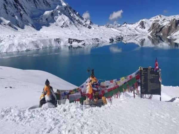
Every trek we run is arranged privately for your group. You will not be paired with strangers unless you choose to join a public departure. Whether you book as a solo trekker, a couple, or a group of friends, this itinerary belongs to you. Want to add a rest day? Extend to include Tilicho Lake? Spend an extra night in Manang? We can adjust. Our three tiers (Budget, Standard and Luxury) give you genuine choice over accommodation, meals, porter support and transport without affecting the route itself. Same expert guides. Same safety standards. Three comfort levels. Read more about what the price difference actually buys or explore budget trekking in Nepal.
Difficulty: Very Challenging (5 out of 5)
This trek earns its 5/5 rating. Thorong La Pass at 5,416 metres is the highest point most trekkers will ever reach on foot. The pass day involves 8–10 hours of walking, starting before dawn at around 4,450 metres and ascending over 900 metres of altitude before descending nearly 1,600 metres to Muktinath. Altitude sickness is a genuine concern above Manang, and the combination of cold, thin air, and sustained effort on pass day demands real physical and mental resilience. Daily walking ranges from 5 to 8 hours over uneven terrain, river crossings, and steep ascents. Our guides carry a pulse oximeter and monitor your oxygen levels daily. We also recommend consulting your doctor about Diamox before departure. If you can comfortably walk 6–8 hours a day on hilly terrain and have a reasonable level of fitness, you can do this trek. If you have concerns, read our beginner’s guide.
Compare Our Three Packages
| Feature | Budget | Standard | Luxury |
|---|---|---|---|
| Price from | USD $720 | USD $999 | USD $1,499 |
| Meals | Not included (order and pay at teahouses) | 3 meals daily + tea, fruits and 2L water | All meals + all drinks (except alcohol) |
| Room | Shared teahouse room | Private twin with attached bathroom | Private deluxe with bed heater |
| Porter | Not included | 1 porter per 2 trekkers | 1 porter per trekker (carry nothing) |
| Guide | 1 guide per group (assistant at 8+) | 1 guide per 6 trekkers (assistant at 6+) | 1 guide per 2 trekkers |
| Transport | Local vehicle | Shared tourist vehicle | Luxury private vehicle |
| SIM & Data | SIM card only | SIM with limited data | SIM with unlimited data (see our SIM card guide) |
| Best for | Backpackers and independent travellers | Comfort trekkers, couples, families | Premium experience seekers |
Himalayas for Every Budget. Same expert guides, same safety, three comfort levels. Every tier includes all permits, a Nepal government well-trained guide, airport transfers and 24/7 emergency support. The only things that change are the comfort details. Read our full comparison of what the price difference actually buys or explore luxury trekking in Nepal. Note: in Pokhara, only breakfast is included at your hotel across all tiers; other meals in Pokhara are at your own expense, giving you the freedom to explore the city’s lakeside restaurants. Check our guide on WiFi and charging on the trail so you know what to expect beyond Chame.
Why we keep the prices honest
Most operators selling the Annapurna Circuit underprice it and skim porters’ wages. We don’t. Our prices include enough margin to pay porters fairly and to send a fixed share of every booking to the Nagarjun Learning Center, our charity school in Saldum village. The school serves seventy children with free year-round classes and two daily meals, and it is registered with the Nepalese government and listed on the UN Partner Portal. The trek you book funds the school directly — no separate donation form, no surprise add-on at checkout.