The Great Himalayan Trail, The Ultimate Mountain Journey on Earth
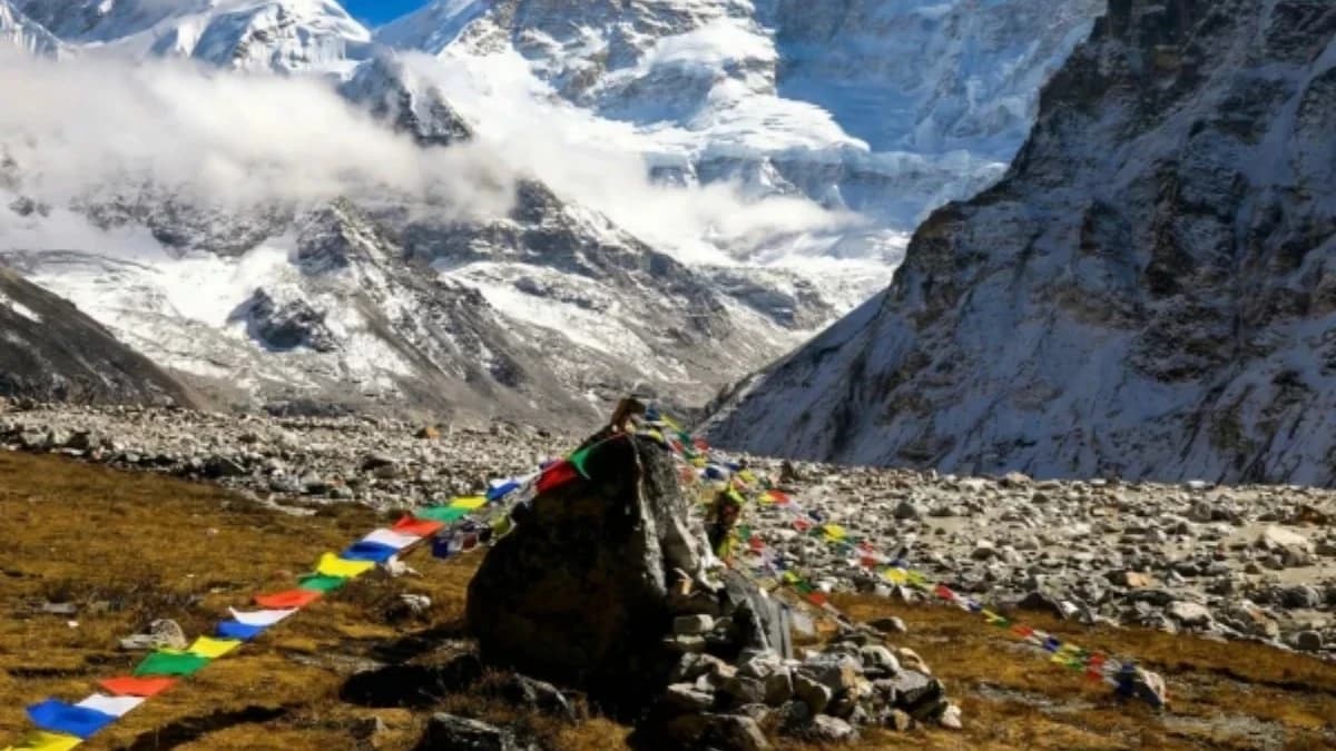
The Great Himalayan Trail is the longest and most challenging mountain trek in the world. A continuous traverse of Nepal 's entire Himalayan range from east to west, from Kanchenjunga on the Tibetan border to Humla on the far western frontier, covering approximately 1,700 kilometres, crossing 20+ passes above 5,000 metres, and accumulating over 150,000 metres of elevation gain and loss. Fewer than 125 people have ever completed it.
This is not a trek we recommend lightly. It demands strong fitness, mountaineering experience, mental resilience, and five to six months of your life. The reward is equally rare: the single greatest long-distance mountain journey on Earth, passing beneath eight of the world 's fourteen highest mountains and through the territories of 15 ethnic groups.
Two Routes, Upper (High) Route and Lower Route
The Great Himalayan Trail actually consists of two distinct routes through Nepal:
The High Route (Upper GHT)
This is the route we offer. It follows the highest possible line across the Nepal Himalaya, staying close to the glacial peaks, crossing technical passes, and traversing some of the most remote terrain on Earth. The High Route includes 2 passes exceeding 6,000 metres and 18 passes over 5,000 metres. It requires mountaineering skills for the glacier crossings and is graded Extreme (Grade 5).
Distance: ~1,700 km | Duration: 140–160 trekking days | Highest point: 6,190m (West Col) | Elevation gain/loss: 150,000m+
The Low Route (Lower GHT)
The Low Route follows Nepal 's mid-hills at lower altitudes, connecting traditional villages and cultural sites. It is longer in distance but technically easier, no mountaineering skills required. The Low Route is more culturally focused, passing through the heartlands of Nepal 's diverse ethnic communities. While we specialise in the High Route, we can design custom Low Route or combined itineraries on request.
Distance: ~1,500 km (mid-hills) | Duration: 100–120 days | Highest point: ~4,500m | Difficulty: Moderate to Challenging
The High Route, 7 Segments, 10 Sections
The High Route is typically divided into 7 operational segments with rest/transit days between them. Each segment covers 1–2 of the 10 geographic sections of Nepal 's Himalayan range.
Segment 1: Kanchenjunga to Makalu (Days 1–21)
Fly from Kathmandu to Taplejung via Bhadrapur. Trek through dense rhododendron forests into the Kanchenjunga Conservation Area. Cross Lumba Sumba Pass (5,159m), Nango La (4,776m), and Lapsang La (5,160m). Views of Kanchenjunga (8,586m), the world 's third highest mountain. Descend through remote Limbu and Sherpa villages to Hongon. This region sees almost no other trekkers.
Key passes: Nango La (4,776m), Lumba Sumba La (5,159m), Lapsang La (5,160m)
Highest point: ~5,160m
Highlights: Kanchenjunga Base Camp, old-growth forest, remote villages
Segment 2: Makalu–Everest Traverse & the Three Cols (Days 22–40)
THE most technically demanding section of the entire trail. Fly to Tumlingtar, trek to Makalu Base Camp (4,870m) through the untouched Barun Valley. Then cross the infamous Three Cols, Sherpani Col (6,180m), West Col (6,190m, the highest point on the entire GHT), and Amphu Laptsa (5,845m). Glacier crossings, crevasse fields, fixed ropes required. The virtually uninhabited Honku Valley. Views of Everest, Lhotse, Makalu, and Baruntse simultaneously. This section alone eliminates most trekkers.
Key passes: Sherpani Col (6,180m), West Col (6,190m), Amphu Laptsa (5,845m)
Highest point: 6,190m (West Col)
Technical requirements: Crampons, ice axe, rope work, glacier travel, crevasse rescue
Segment 3: Everest Region & Rolwaling (Days 41–62)
Descend to Chukhung, then traverse the Khumbu region via Cho La (5,420m) and Renjo La (5,360m). Everest Base Camp, Kala Patthar (5,545m), Gokyo Lakes. Namche Bazaar is a major resupply point, ATMs, shops, WiFi. Then cross Tashi Laptsa (5,760m), extremely technical with glacier crossings, rockfall danger, and fixed ropes, descending through the Trakarding Glacier into the sacred Rolwaling Valley. The legendary home of the Yeti. Tsho Rolpa glacial lake.
Key passes: Cho La (5,420m), Renjo La (5,360m), Tashi Laptsa (5,760m)
Highest point: 5,760m (Tashi Laptsa)
Highlights: EBC, Gokyo Lakes, Namche resupply, Rolwaling Valley
Segment 4: Helambu–Langtang–Manaslu (Days 63–88)
Drive to Suri Dhovan, then trek through the Gaurishankar range. Cross Tilman 's Pass (5,320m) into Langtang National Park. Visit the rebuilt Langtang Village and the sacred Gosaikunda Lakes (4,380m). Continue through the Ruby Valley and Ganesh Himal into the Manaslu Conservation Area (restricted). Cross Larkya La (5,106m) with views of Manaslu (8,163m), the world 's eighth highest. Option to include the sacred Tsum Valley.
Key passes: Tilman 's Pass (5,320m), Laurebina La (4,610m), Larkya La (5,106m)
Highlights: Langtang Valley, Gosaikunda Lakes, Manaslu views, Tsum Valley option
Segment 5: Annapurna & Upper Mustang (Days 89–110)
The Annapurna Conservation Area and the classic Annapurna Circuit. Cross Thorong La (5,416m) and Mesokanto La (5,099m). Muktinath temple. Tilicho Lake (4,919m). Option to include Upper Mustang, the former forbidden kingdom with Tibetan Buddhist culture. Jomsom is a major resupply point with an airport.
Key passes: Thorong La (5,416m), Mesokanto La (5,099m)
Highlights: Annapurna Circuit, Muktinath, Tilicho Lake, Upper Mustang option
Segment 6: Dolpo (Days 111–135)
Fly from Nepalgunj to Juphal. Enter Shey Phoksundo National Park, Nepal 's largest. Phoksundo Lake, the deepest lake in Nepal, a deep turquoise. Upper Dolpo was the inspiration for Peter Matthiessen 's “The Snow Leopard.” Crystal Mountain. Bon Buddhist monasteries. Snow leopard habitat. One of the most remote regions in Nepal. Full camping, no teahouses. Cross Kagmara La (5,115m), Baga La (5,190m), and Numa La (5,190m).
Key passes: Kagmara La (5,115m), Baga La (5,190m), Numa La (5,190m)
Highlights: Phoksundo Lake, snow leopard territory, Bon Buddhist culture, complete wilderness
Segment 7: Rara Lake, Humla & the Finish (Days 136–154)
Rara Lake, Nepal 's largest and most beautiful lake. The Mugu region and Limi Valley with remote Tibetan villages. Simikot (Humla district headquarters). Final approach to Hilsa on the Tibetan border, the end of the trail. Extremely remote far-western Nepal, very few foreigners have ever been here.
Key passes: Chankheli Pass (3,850m), Nyalu Lagna (4,980m)
Highlights: Rara Lake, Limi Valley, Hilsa border, the end of Nepal
All Key Passes, Complete Table
| Pass | Altitude | Segment | Technical? |
|---|---|---|---|
| Nango La | 4,776m | 1 | No |
| Lumba Sumba La | 5,159m | 1 | No |
| Lapsang La | 5,160m | 1 | No |
| Sherpani Col | 6,180m | 2 | Yes, glacier, ropes |
| West Col | 6,190m | 2 | Yes, highest point |
| Amphu Laptsa | 5,845m | 2 | Yes, ice, rock |
| Cho La | 5,420m | 3 | Some scrambling |
| Renjo La | 5,360m | 3 | No |
| Tashi Laptsa | 5,760m | 3 | Yes, glacier, rockfall |
| Tilman 's Pass | 5,320m | 4 | Some scrambling |
| Laurebina La | 4,610m | 4 | No |
| Larkya La | 5,106m | 4 | No |
| Thorong La | 5,416m | 5 | No |
| Mesokanto La | 5,099m | 5 | No |
| Kagmara La | 5,115m | 6 | No |
| Baga La | 5,190m | 6 | No |
| Numa La | 5,190m | 6 | No |
| Nyalu Lagna | 4,980m | 7 | No |
What Makes This the Hardest Trek on Earth
-
Duration: 150+ days of continuous trekking with no real rest. Far harder than climbing any single mountain.
-
Technical passes: The Three Cols require full mountaineering skills, fixed ropes, glacier travel, crevasse rescue capability. Tashi Laptsa involves rockfall danger and glacier crossings.
-
Cumulative elevation: Over 150,000 metres of total ascent and descent across five months. “Always either on a steep uphill to a pass or a steep downhill to a river.”
-
Altitude: 2 passes above 6,000m, 18 passes above 5,000m. Constant altitude sickness risk across months.
-
Remoteness: In Dolpo and Humla, you are days from any road, airstrip, or medical facility.
-
Navigation: The GHT is not a single marked trail. It is a concept linking existing paths, passes, and routes. In western Nepal, trails disappear entirely.
-
Resupply: In western Nepal, food and fuel must be carried for 20+ day stretches. No shops, no teahouses, no civilisation.
-
Completion rate: Only approximately 125 people have ever completed the full High Route since its establishment.
Camping vs Teahouse
Approximately 60–70% of the High Route requires full expedition camping. Teahouse accommodation is available in the Khumbu/Everest section, parts of the Annapurna Circuit, parts of Langtang, and the Manaslu Circuit (basic). All expedition camping equipment is provided as part of our package.
Resupply Points
Major resupply points along the route (east to west):
- Taplejung, start, full supplies, airport
- Tumlingtar, airport, moderate supplies
- Namche Bazaar, major resupply (ATMs, shops, WiFi, bakeries)
- Lukla, airport, good supplies
- Syabrubesi, moderate, road access
- Arughat, moderate, road access
- Jomsom, major resupply point, airport
- Juphal/Dunai, moderate, airstrip
- Jumla, moderate, airstrip
- Simikot, basic supplies, airstrip (final resupply)
History of the GHT
The Great Himalayan Trail was conceptualised by Robin Boustead, a British-New Zealand adventurer who spent five years researching the route before walking it over two seasons (162 days total). His guidebook “Nepal Trekking & the Great Himalaya Trail” remains the primary reference for the route.
Apa Sherpa, who summited Everest 21 times, more than anyone in history at that time, led the first complete GHT expedition in April 2012 alongside Dawa Steven Sherpa, completing the 1,555 km route in just 99 days.
The Fastest Known Time is held by South Africans Ryan Sandes and Ryno Griesel, 24 days, 3 hours, 24 minutes, set in March 2018. They were running, not trekking.
The trail crosses through the territory of 15+ ethnic groups including Sherpa, Tamang, Gurung, Thakali, Magar, Rai, Limbu, and Tibetan communities. The Dolpo section is where Peter Matthiessen wrote his classic “The Snow Leopard” (1978).
Permits Required
The GHT requires the most complex permit stack of any trek on Earth, 15+ separate permits across restricted areas and national parks:
| Permit | Area | Cost (per person) |
|---|---|---|
| Kanchenjunga Conservation Area + Restricted | Segment 1 | ~ |
| Makalu-Barun National Park | Segment 2 | ~ |
| Sagarmatha National Park | Segment 3 | ~ |
| Gaurishankar Conservation Area | Segment 3 | ~ |
| Langtang National Park | Segment 4 | ~ |
| Manaslu Restricted Area | Segment 4 | –100/week |
| Annapurna Conservation Area (ACAP) | Segment 5 | ~ |
| Upper Mustang Restricted Area | Segment 5 (option) | /10 days |
| Shey Phoksundo National Park | Segment 6 | ~ |
| Dolpo Restricted Area | Segment 6 | /10 days (Upper) or /week (Lower) |
| Humla Restricted Area | Segment 7 | /week |
| Rara National Park | Segment 7 | ~ |
Total permits: approximately ,000–3,500 per person. All permits are included in our package price.
Who This Trek Is For
-
Previous high-altitude experience, at least two treks above 5,000m completed
-
Mountaineering skills, crampon use, rope work, glacier travel. This is not the trek to learn on.
-
Strong fitness, walking 6–8 hours daily for five months with a pack
-
Mental resilience, weeks of isolation, basic camping, unpredictable weather
-
5–6 months of available time, this is an expedition, not a holiday
-
Full insurance covering helicopter evacuation to 6,200m for the full duration
Can I Do the GHT in Sections?
Yes. Many trekkers complete the GHT in 2–4 separate expeditions over consecutive years. We can design section-based itineraries. The most popular standalone sections are:
- Kanchenjunga section (18–20 days)
- The Three Cols, Makalu to Everest (12–15 days), the most technically demanding
- Dolpo (20–25 days), the most remote and culturally unique
- Manaslu + Annapurna combined (30–35 days)
Why Trek the GHT with The Everest Holiday?
-
IFMGA-certified lead guide for the entire 150-day expedition
-
Full logistical support, 12–16 porters, cook team, assistant guides, rotating through sections
-
All 15+ permits handled, restricted areas, national parks, conservation areas
-
Satellite communication, Garmin inReach and satellite phone. Daily GPS tracking shared with your emergency contacts
-
Emergency infrastructure, helicopter evacuation standby for the entire expedition. Portable altitude chamber (Gamow bag)
-
Resupply logistics, food and fuel drops coordinated across remote western Nepal
-
Technical equipment provided, mountaineering ropes, crampons, ice axes, harnesses, anchors
-
Secure payment, staged payments through Himalayan Bank Limited
-
24/7 operations desk in Kathmandu monitoring the expedition throughout